

Project Overview
Copeçal Gold Project | Mato Grosso, Brazil

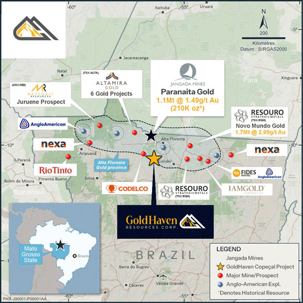
Copeçal is located in the Alta Floresta–Juruena mineral belt, a proven gold-producing region known for multiple deposit styles, including shear-related, intrusion-related, porphyry-style, and epithermal gold systems.
The project is supported by a significant historical exploration database. Between 2010 and 2016, AngloGold Ashanti completed systematic work across the property, including auger and air-core drilling, geophysics, soil geochemistry, and rock geochemistry. This work outlined multiple zones of anomalous gold mineralization, including a district-scale gold-in-soil anomaly extending approximately 6 kilometres.
GoldHaven has since advanced the project with modern exploration, including 107 auger drill holes totaling 2,153 metres, VLF-EM surveying, drone magnetic surveys, geochemical interpretation, geophysical modelling and structural analysis that all lead to first-pass diamond drilling in Q4 2025.
The result is a stronger, more focused exploration model backed by historical data, modern geophysics, drill core, and independent technical validation.
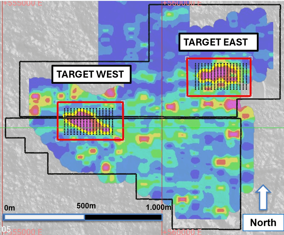
GoldHaven’s first diamond drilling campaign tested whether Copeçal’s broad surface gold anomaly is connected to an in-situ mineralized system at depth.
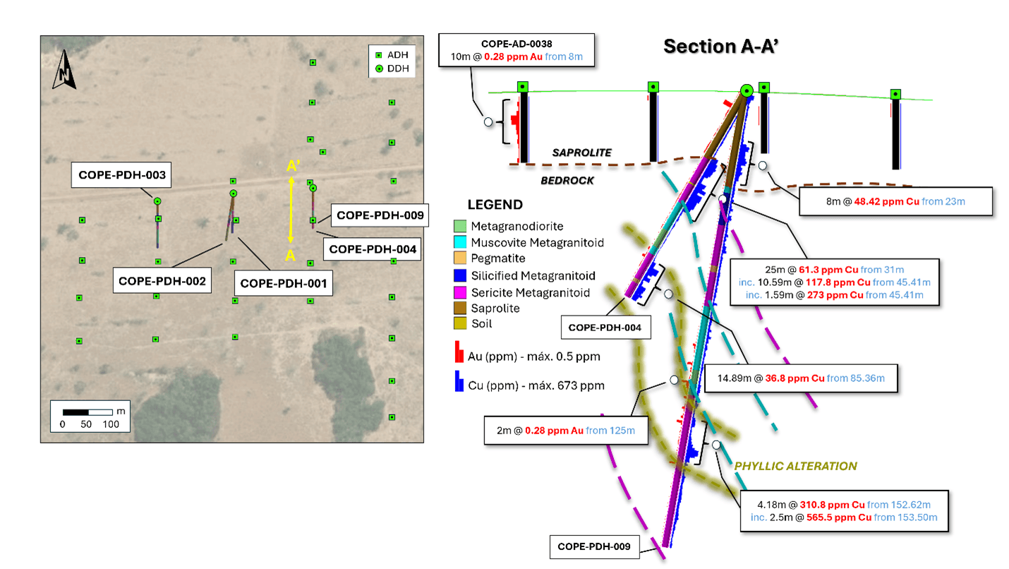
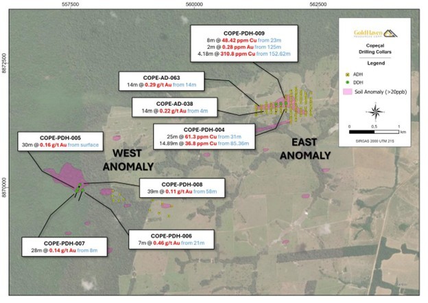
The program completed nine diamond drill holes totaling 1,085.7 metres across the West and East targets. At the West Target, drilling confirmed gold mineralization in all four holes, including gold in unweathered granodiorite-gneiss beneath a deep saprolite profile. At the East Target, drilling intersected sulphide mineralization, copper-gold anomalism, phyllic alteration, and structural deformation.
Key outcomes from the initial program include:

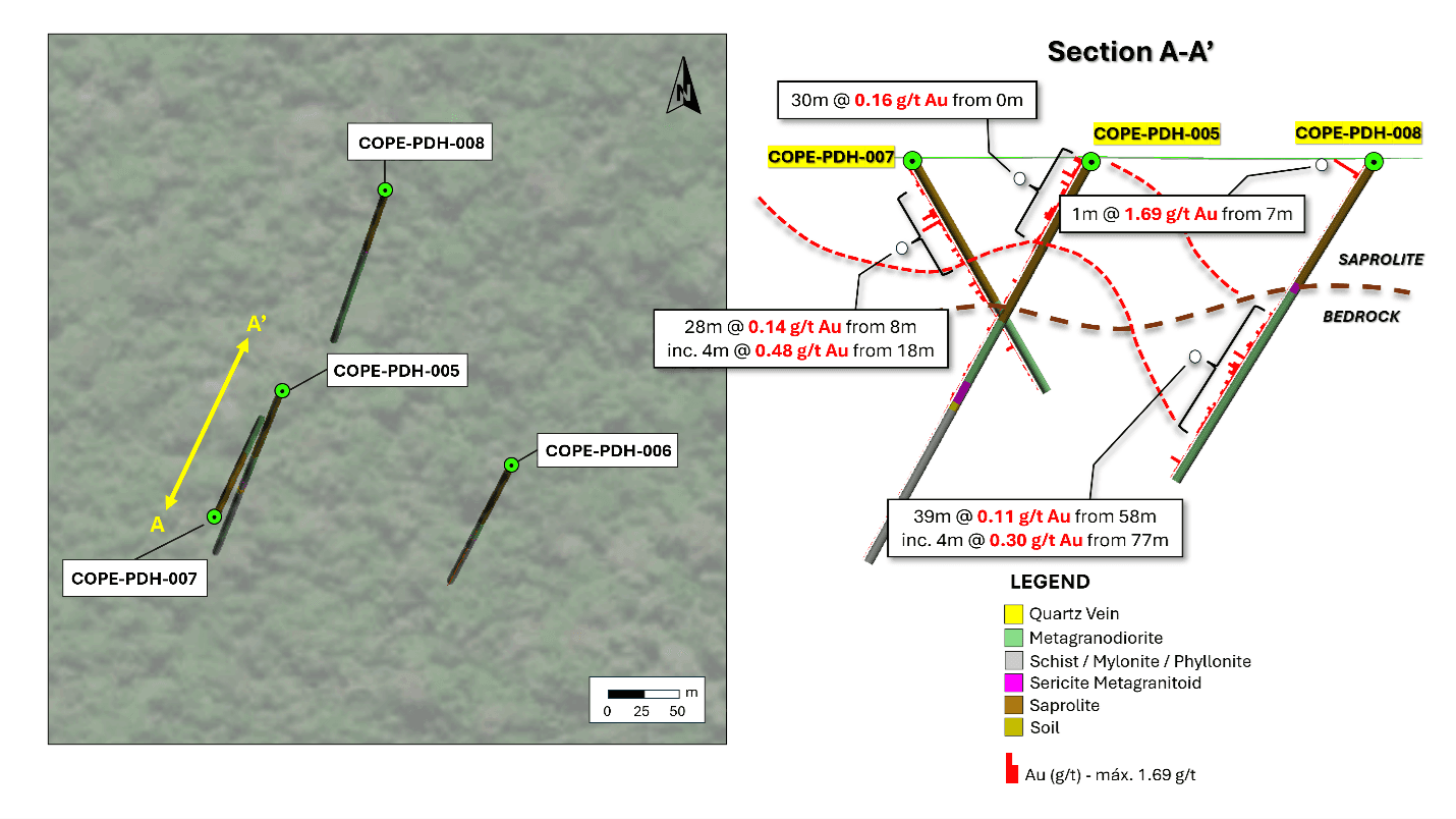
Gold mineralization confirmed in all four West Target drill holes and bedrock gold mineralization confirmed at Copeçal West;
A deep saprolite profile identified at the West Target, extending to approximately 60 metres downhole;
Sheeted quartz veining, phyllic alteration, shearing, folding, and deformation observed in drill core;
Sulphide mineralization intersected at the East Target, including chalcopyrite, pyrite, and bornite;
Multiple high-priority structural and geophysical targets identified for Phase II.
The campaign confirmed that Copeçal is more than a surface anomaly. It is now interpreted as a drill-confirmed hydrothermal system with clear vectors for follow-up exploration.
GoldHaven confirmed gold mineralization in all four West Target holes, with mineralization hosted in both saprolite and bedrock. The most important result came from hole COPE-PDH-008, which confirmed gold mineralization in unweathered granodiorite-gneiss beneath the weathered profile.
The recent independent review further strengthened the West Target model. Higher-grade gold enrichment is associated with asymmetric to isoclinal fold structures, dense sheeted quartz veinlet systems, and phyllic altered meta-granodiorite. Potassic alteration, including crystalline biotite along quartz vein margins, points to a robust hydrothermal system with potential along strike to the west and at depth.
Importantly, the core of the West Target gold-in-soil anomaly remains largely untested and aligns with a fold hinge and closure zone interpreted from drone magnetic data — making it a high-priority Phase II target.
Initial drilling intersected sulphide mineralization, copper-gold anomalism, phyllic alteration, and structural deformation. Hole COPE-PDH-004 intersected approximately 30 metres of sulphide mineralization, including chalcopyrite and pyrite. Follow-up hole COPE-PDH-009 intersected approximately 5 metres of bornite, chalcopyrite, and pyrite, marking the first observed occurrence of bornite at Copeçal.
The independent review confirmed the East Target as a northerly dipping, shear-hosted mineralized zone with zoned sulphide assemblages. The transition from chalcopyrite-pyrite to chalcopyrite-bornite is interpreted as a temperature vector that may point toward stronger mineralization at depth and along strike.
Together, the East and West targets provide multiple opportunities for follow-up drilling across a broader hydrothermal system.
Copeçal has the key ingredients investors look for in an emerging gold exploration story: scale, structure, alteration, sulphides, gold-copper anomalism, quartz veining, and drill-confirmed mineralization.
The independent specialist geology consultant review confirms Copeçal’s potential as a large-scale, structurally controlled hydrothermal system. At the West Target, gold enrichment is linked to fold hinge structures and increasing sheeted vein density. At the East Target, zoned sulphide assemblages provide a temperature vector toward potentially stronger mineralization.
This is the key shift in the Copeçal story: GoldHaven is no longer working from surface anomalies alone. The Company now has first-ever drill confirmation, independent technical validation, and multiple high-priority targets ready for Phase II drill testing.
GoldHaven is planning a Phase II drill program to test high-priority targets across the Copeçal system starting in Q2/Q3 2026.
Phase II targeting is expected to focus on areas where gold anomalism, structural preparation, alteration, veining, sulphide zonation, and geophysical features converge.
Current priorities include:
Follow-up drilling of fold hinge and closure targets at the West Target;
Testing mineralization vectors at depth and along strike at the East Target;
Integrating drone magnetic data with geochemistry, alteration, and structural interpretation;
Evaluating the broader 6-kilometre gold-in-soil anomaly;
Expanding drilling across underexplored portions of the system.
The project has moved from historical anomalies to first-ever drilling, from drill confirmation to independent geological validation, and now toward a focused Phase II program targeting the large-scale hydrothermal system.
With a 6-kilometre gold-in-soil anomaly, extensive historical AngloGold Ashanti data, modern geophysics and auger drilling, drill-confirmed bedrock mineralization, and high-priority targets identified by independent review, Copeçal offers GoldHaven a clear path to advance its key gold asset.
GoldHaven’s mission at Copeçal is clear: turn years of data and preparation into a discovery that positions Goldhaven as a leader in the next generation of gold exploration in one of Brazil’s most prospective gold provinces.


